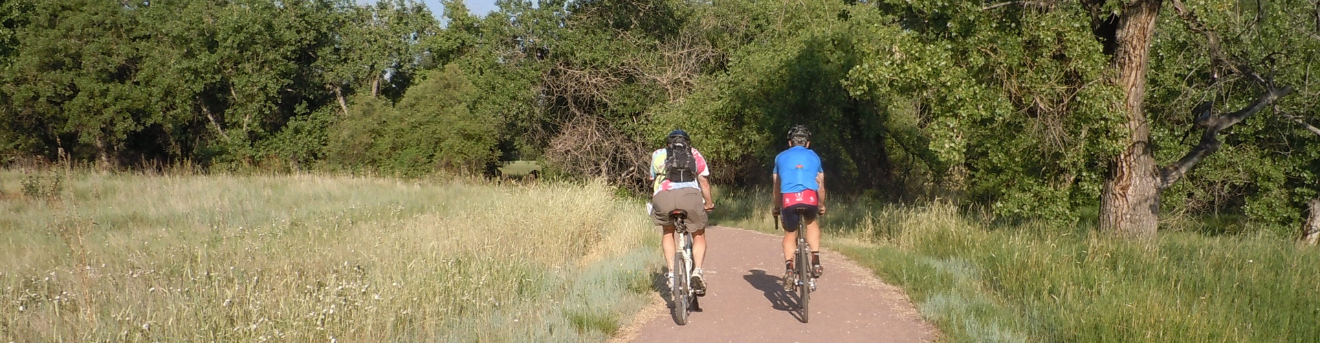
The Coal Creek Trail is a soft-surface trail that parallels Coal Creek from 66th Street in Superior to Erie.
Coal Creek Trail
| Trails |
|---|
Coal Creek Trail     14 miles – Easy |
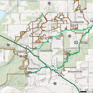
Trails Connections
The Coal Creek Trail connects with these trails and properties.
Parking
- Aquarius Trailhead has eight car spaces and two school bus spaces.
- Flagg Park Trailhead has 18 car spaces, an ADA parking space and two horse trailer spaces.
- South Public Road Trailhead has nine car spaces.
Picnic Areas
- Group shelter available at the Aquarius Trailhead
Restrooms
- Flagg Park Trailhead
Keep in Mind
- Pedestrians, bicyclists, and dogs are allowed on the trails.
- Equestrians are not allowed on a majority of the trails due to city of Lafayette and Louisville regulations.
- Regional trails and regional trail connectors are open to commuters 24 hours per day. Trailheads close at sunset and parking is not allowed between sunset and sunrise.
Documents
As a riparian (streamside) ecosystem, expect to see many water-loving species.
Mammals
- Coyote
- Raccoon
- Red Fox
- Skunk
Reptiles & Amphibians
- Boreal chorus frog
- Bull snake
- Plains garter snake
Birds
- American kestrel
- Black crowed night-heron
- Black-billed magpie
- Great horned owl
- Northern flicker
- Red tailed hawk
- Red winged blackbird
Insects
- American rubyspot
- Bluets
- Convergent lady beetle
- Gray hairstreak
- Great golden digger wasp
- Painted lady
- Scarlet malachite beetle
- Small milkweed bug
- Striped meadowhawk
Trees & Shrubs
- American plum (Prunus americana)
- Chokecherry (Prunus virginiana)
- Golden currant (Ribes aureum)
- Narrow leafed willow (Salix exigua)
- Peachleaf willow (Salix amygdaloides)
- Plains cottonwood (Populus deltoides)
Grasses
- Foxtail barley (Hordeum jubatum)
- Witch grass (Panicum capillare)
Pink & Purple Wildflowers
- Crossflower (Chorispora tenella)
- Hemp dogbane (Apocynum androsaemifolium)
- Lewis flax (Linum lewisii)
- Rocky mountain bee plant (Cleome serrulate)
- Showy milkweed (Asclepias speciose)
- Western spiderwort (Tradescantia occidentalis)
White Wildflowers
- Prickly poppy (Argemone polyanthemos)
- White prairie clover (Dalea candida)
- Wild licorice (Glycyrrhiza lepidota)
Yellow Wildflowers
- Common St. John’s wort (Hypericum perforatum)
- Curlycup gumweed (Grindelia squarrosa)
- Fern leaf yarrow (Achillea filipendulina)
- Hairy false goldenaster (Heterotheca villosa)
- Prickly pear (Opuntia sp.)
- Yellow salsify (Tragopogon dubius)
The Coal Creek Regional Trail is a 14-mile of soft-surface trail that parallels Coal Creek, from South 66th Street in Superior through Louisville and Lafayette to Vista Parkway in Erie. For locals, the trail offers access to nature just steps from home while it also provides a corridor for wildlife.
Starting in 1990, the Coal Creek and Rock Creek Trails project is the product of an area-wide partnership. Boulder County, the Town of Superior, the cities of Louisville and Lafayette, and the Urban Drainage and Flood Control District, all worked and will continue to work together to ensure the trail’s completion.