Heil Valley Ranch
View from Picture Rock Trail

Heil Valley Ranch

Checking for closures…

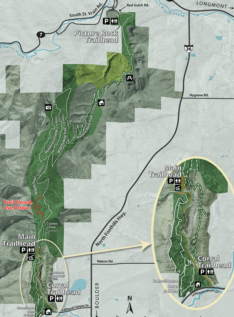
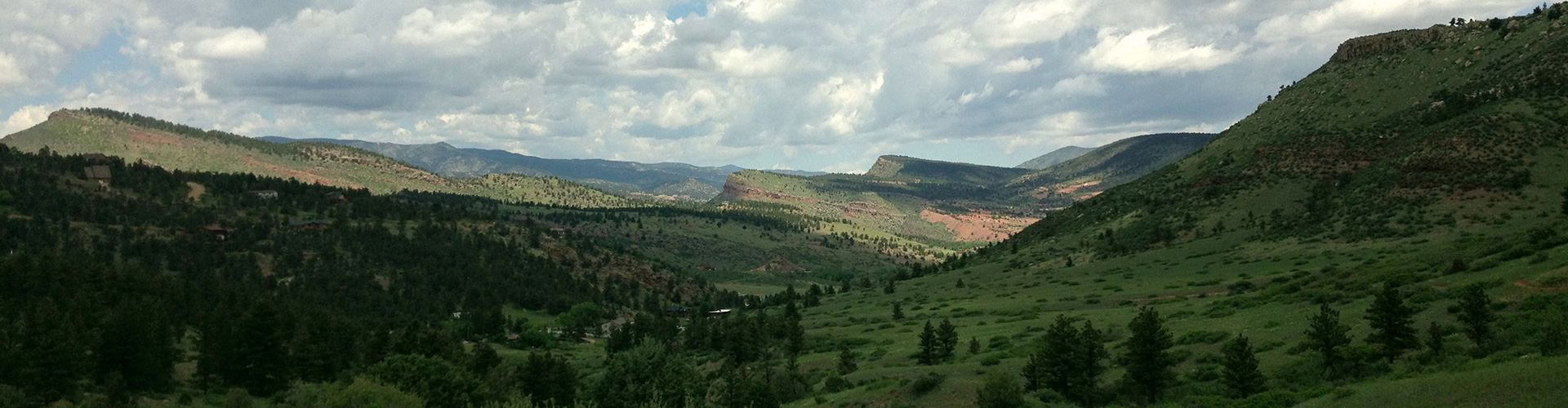
With beautiful valleys, picturesque vistas, and forest meadows that seem to cling to the sky, Heil Valley Ranch offers a day’s adventure in the foothills.

Trails

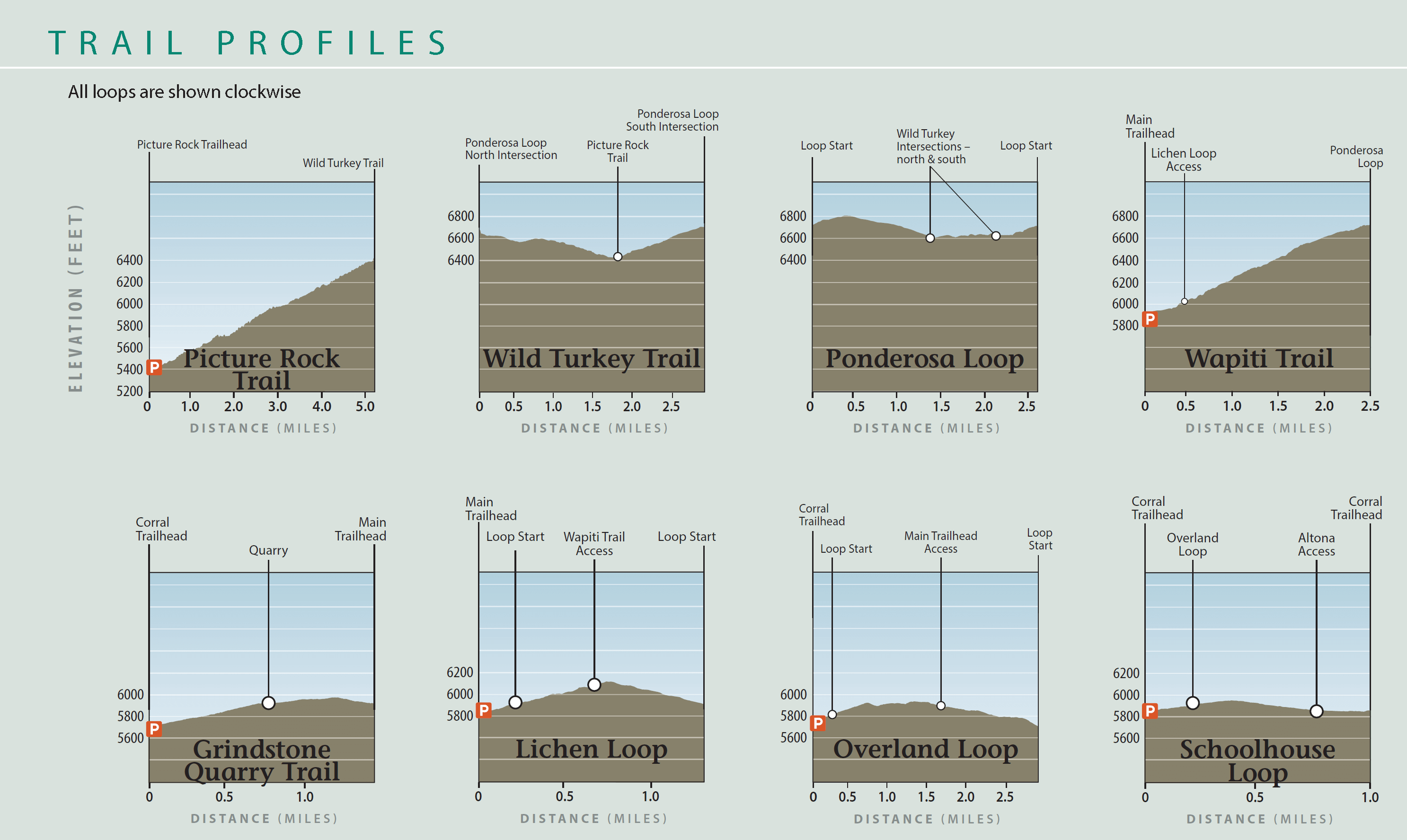
  • Grindstone Quarry Trail

    1.4 miles – Easy

    Hiking Allowed Dogs Prohibted Bikes Prohibted No E-bikes Allowed Horses Allowed
  • Lichen Loop

    1.3 miles – Easy

    Hiking Allowed Dogs Prohibted Bikes Prohibted No E-bikes Allowed Horses Prohibted
  • Overland Loop

    2.3 miles – Moderate
    Bike Direction: Clockwise

    Hiking Allowed Dogs Prohibited Bikes Allowed No E-bikes Allowed Horses Allowed
  • Picture Rock Trail

    5.2 miles – Moderate

    Hiking Allowed Dogs Prohibited Bikes Allowed No E-bikes Allowed Horses Allowed
  • Ponderosa Loop

    2.6 miles – Moderate

    Hiking Allowed Dogs Prohibited Bikes Allowed No E-bikes Allowed Horses Allowed
  • Schoolhouse Loop

    0.9 miles – Easy
    Bike Direction: Counterclockwise

    Hiking Allowed Dogs Prohibited Bikes Allowed No E-bikes Allowed Horses Allowed
  • Wapiti Trail

    2.5 miles – Moderate

    Hiking Allowed Dogs Prohibited Bikes Allowed No E-bikes Allowed Horses Allowed
  • Wild Turkey Trail

    2.9 miles – Moderate

    Hiking Allowed Dogs Prohibited Bikes Allowed No E-bikes Allowed Horses Allowed

Graphs showing elevations of the trails at Heil Valley Ranch

Main Trailhead

59 car parking spots
3 ADA parking spots
Restroom near trailhead
2 horse trailer/bus parking spots*
Several picnic tables located near parking lots
Large 50 person group shelter located near trailhead

*The horse trailer/bus parking spots are closed until Dec. 22 for construction.

Corral Trailhead

19 car parking spots
1 ADA parking spot
Restroom near trailhead
4 horse trailer/bus parking spots
1 picnic table
Live view of Corral Trailhead
Live view of the Corral Trailhead Parking Lot. More photos below.

Picture Rock Trailhead

25 car parking spots
2 ADA parking spots
Restroom near trailhead
3 horse trailer/bus parking spots

Geer Canyon Rd. Overflow Parking

12 car parking spots

Rules & Regulations

Day Use Only
On Trail Use Only
No Pets Allowed
Bikes On Designated Trails Only
No Collecting
No Hunting/Firearms
No Camping
No Open Fires

Wapiti Trail

Detour

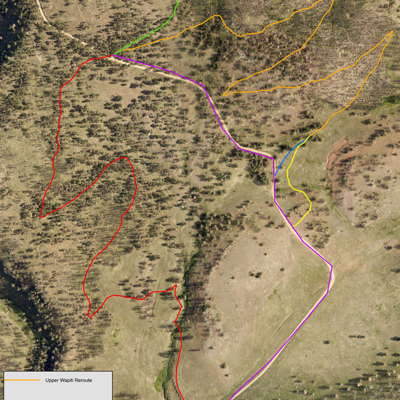
A section of the Wapiti Trail is closed to protect golden eagles. Please follow the detour along the emergency access road.

Golden eagles built a nest in the area during the closure. Boulder County works with Colorado Parks and Wildlife and the U.S. Fish and Wildlife Service to ensure protection of sensitive species. Staff follows federal guidance, such as the Bald and Golden Eagle Protection Act, and the detour allows a half-mile buffer zone between the nest site and areas of human activity. The detour will be in place year-round for the next several years.

New Route Coming Soon

A new route for the Wapiti Trail has been defined and construction has started. The United States Fish & Wildlife Service approved the reroute that will be north of the access road currently being used as the detour. The permanent trail will only use a small portion of the access road. Construction is expected to continue through 2024 with an expected opening date of mid to late summer 2024.

Wapiti Trail Reroute Map

Wapiti Trail Reroute at Heil Valley Ranch Trail Map

Skills Loop and Schoolhouse Loop

The Skills Loop and Schoolhouse Loop are great trails for beginning mountain bikers and can be accessed from the Corral Trailhead.

The short Skills Loop lets riders practice going over and around various obstacles that commonly encountered on the trails. The trail ends with a ride through a boxcar rail car.

The Schoolhouse Loop is an easy, 0.9 miles long trail that is perfect for entry-level mountain bikers.

Keep in Mind

  • The south side of the park was severely affected by the Cal-Wood Fire. Learn more about recovery efforts.
  • Dogs are not allowed due to wildlife concerns.
  • Conservation areas are closed to the public to protect critical wildlife habitat.
  • Emergency access roads exist on the property. Visitors are urged to stay on designated trails since these roads do not always lead to trailheads.
  • While mullein, thistles, and other invasive weed species were present before the Cal-Wood Fire, they are especially prevalent on the post-fire landscape. Please stay on trail and clean off seeds from clothing, backpacks, and bikes after visiting to keep weeds from spreading to other open space areas. These weeds are expected to gradually decrease over the course of five to 10 years as more native species return.

Flash Flooding and Main Trailhead Parking Lot Closures

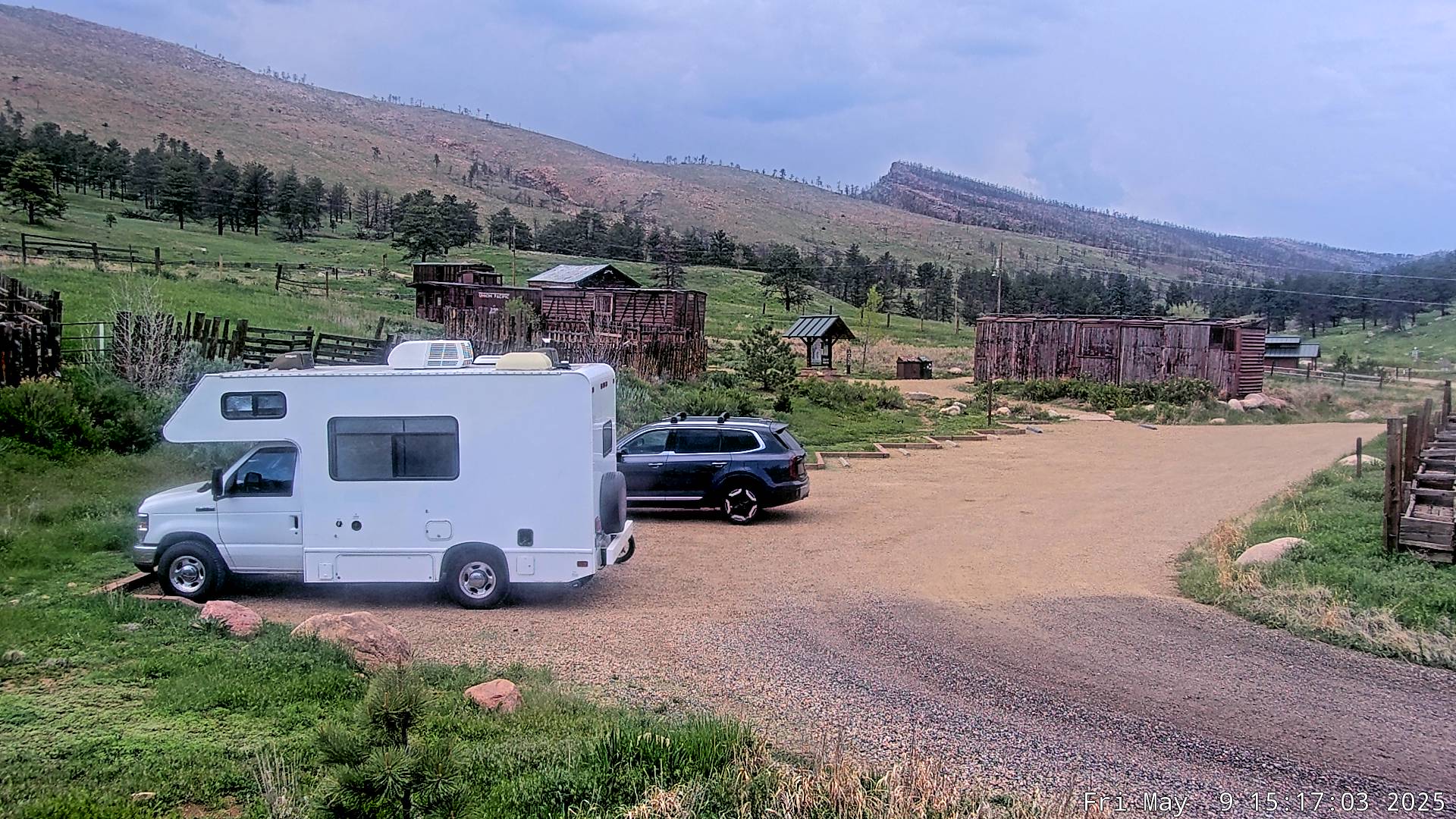
During the summer monsoon season, the Main Trailhead parking lot may be closed if weather reports indicate the potential for heavy rains, flash flooding, or debris flows. Due to the unpredictable nature of monsoonal storms, these closures may occur at any time. If the gate to the Main Trailhead is closed, visitors should park elsewhere to access the trails and be aware of changing weather conditions, flood safety routes, and locations where they can climb to safety. Notice of closures will be posted as soon as possible.

Know Before You Go

  1. Check the weather forecast.
  2. Visit another park if rain is anticipated.
  3. Sign up for emergency alerts.

Be Prepared When at Heil Valley Ranch

  1. As you travel on trail, identify the flood safety routes.
  2. Keep your eyes on the sky! You may not be able to receive text messages, alerts, or hear sirens.
  3. Leave if storm clouds are building.
  4. Do not drive if you see flooding. Never drive through water if you cannot see the road beneath the water. The road may not be intact under floodwaters.

Emergency Alerts

Visitors are encouraged to sign up to receive reverse 911 emergency messages for potential flooding. Messages are generated by the Office of Emergency Management using Everbridge Alerts.

To add Heil Valley Ranch, use the following address:

1188 Geer Canyon Rd., Boulder CO 80302

Sign Up

Please note, messages can only be received if you have cellular service. The park has limited service depending on the exact area and service provider.

Thoughts from the Public

When Heil Valley Ranch reopened on June 16, 2022, after the devastating Oct. 17, 2020, Cal-Wood Fire, two stations were set up (one on the Lichen Loop and one on the Wapiti Trail) with a prompt to “take a moment to share your thoughts about Heil Valley Ranch reopening.”

The 6,231 acres of Heil Valley Ranch are home to over 50 species of mammals representing 70 percent of all the mammals found in Boulder County. Nearly 100 types of birds call this area home. Golden eagles and prairie falcons nest in the cliffs and canyons. The variety of wildlife found here is partly due to the diversity of vegetation. Much of the land is covered by ponderosa pine forest. Among the ponderosa pines, a variety of shrubs, grasses, and wildflowers thrive providing coverage for small mammals and food for deer.

Mammals

  • Abert’s squirrel
  • Black bear
  • Bobcat
  • Chickaree
  • Coyote
  • Deer mouse
  • Elk
  • Little brown bat
  • Meadow vole
  • Mountain (Nuttall’s) cottontail
  • Mountain lion
  • Mule deer
  • Red fox
  • Rock squirrel

Birds

  • American crow
  • American kestrel
  • American robin
  • Black-billed magpie
  • Broad-tailed hummingbird
  • Brown-headed cowbird
  • Canyon wren
  • Chipping sparrow
  • Cliff swallow
  • Cordilleran flycatcher
  • Common nighthawk
  • Common raven
  • Downy woodpecker
  • Dusty grouse
  • Golden eagle
  • Great horned owl
  • Hairy woodpecker
  • House wren
  • Lazuli bunting
  • McGillivray’s warbler
  • Mountain bluebird
  • Mountain chickadee
  • Northern flicker
  • Prairie falcon
  • Pygmy nuthatch
  • Red-tailed hawk
  • Rufous-sided (spotted) towhee
  • Solitary vireo
  • Scrub jay
  • Steller’s jay
  • Townsend’s solitaire
  • Violet-green swallow
  • Virginia’s warbler
  • Western bluebird
  • Western meadowlark
  • Western wood-pewee
  • Wild turkey
  • White-breasted nuthatch
  • Yellow-breasted chat

Amphibians & Reptiles

  • Bullsnake
  • Eastern fence lizard
  • Plains garter snake
  • Prairie rattlesnake
  • Racer
  • Western terrestrial garter snake

White Wildflowers

  • Daisy fleabane (Erigeron sp)
  • Easter daisy (Townsendia grandiflora)
  • Mariposa lily (Calochortus gunnisonii)
  • Miner’s candle (Cryptantha virgate)
  • Mouse ear chickweed (Cerastium sp)
  • Nodding onion (Allium cernuum)
  • Plains larkspur (Delphinium carolinianum)
  • Prickly poppy (Argemone polyanthemos)
  • Pussytoes (Antennaria spp)
  • Stemless evening primrose (Oenothera caespitosa)
  • Wild onion (Allium textile)
  • Yarrow (Achillea lanulosa)

Yellow Wildflowers

  • Blanketflower (Gaillardia aristata)
  • Cinquefoil (Drymocallis spp)
  • Golden banner (Thermopsis divaricarpa)
  • Gumweed (Grindelia squarrosa)
  • Hairy false golden aster (Heterotheca villosa)
  • Stonecrop (Amerosedum lanceolatum)
  • Sulphur flower (Eriogonum umbellatum)
  • Sunflower (Helianthus sp)

Pink & Red Wildflowers

  • Ball cactus (Coryphantha vivipara)
  • Showy milkweed (Asclepias speciosa)
  • Wild geranium (Geranium caespitosum)

Green Wildflowers

  • Fringed (silver) sage (Artemisia frigida)
  • White (prairie) sage (Artemisia ludoviciana)

Purple & Blue Wildflowers

  • Horsemint (Monarda fistulosa)
  • Blue flax (Adenolinum spp.)
  • Colorado loco (Oxytropis lambertii)
  • Common harebell (Campanula rotundifolia)
  • Fleabane (Erigeron sp)
  • Gayfeather (Liatris punctuta)
  • Larkspur (Delphinium nutallianum)
  • Low Penstemon (Penstemon virens)
  • One-sided penstemon (Penstemon secundiflorus)
  • Pasqueflower (Pulsatilla ludoviciana)
  • Silver lupine (Lupinus argenteus)

Shrubs & Cactus

  • Common juniper
  • Mountain maple
  • Mountain mahogany
  • Oregon grape
  • Prickle-pear cactus
  • Rabbitbrush
  • Three-leaf sumac
  • Yucca

Trees

  • Douglas fir
  • Ponderosa pine
  • Rocky Mountain juniper

At Heil Valley Ranch you see the dramatic landscape where the Great Plains meet the Southern Rocky Mountains. The eastern-most ridge (hogback) at Heil Valley Ranch is capped by a rock layer called the Dakota Formation. On the west side of this property is another series of ridges that look red; this is the Lyons sandstone. This fine-grained sandstone, named after the town of Lyons, has been quarried locally and used for building throughout Boulder County.

From Mountainside To University

The Whitestone and Vickery Quarry Complex along the Picture Rock Trail operated from the 1890s to the 1960s. It was one of the more important quarry operations in the Lyons area. Lyons sandstone was mined there and can be seen in buildings on the University of Colorado campus.

Heil As Home

Four prehistoric sites (i.e. Native American sites used prior to contact with Anglo settlers) are on the property at Heil Valley Ranch. The first Anglo populations in the area were most likely beaver trappers exploring nearby rivers in the late eighteenth and early nineteenth centuries. One of the first Anglo females to reside in Boulder County was Nancy Phinox Geer, who settled here with her husband Solomon Geer in 1888.

Historic Buildings

You may spot a few old stone buildings used by ranch hands, as well as a silo in a meadow up the Picture Rock trail.

Acquisition

The majority of Heil Valley Ranch was purchased in 1993 and 1994 as part of the North Foothills Open Space that includes Hall Ranch and surrounding conservation easement properties.

Cal-Wood Fire

The Cal-Wood Fire started on Oct. 17, 2020, and raced downwind and downslope through Heil Valley Ranch. It consumed 5,000 acres in about five hours. In the end, it covered over 10,000 acres with more than half of that on Boulder County owned property (4,400 acres) and conservation easements (1,400 acres).

Contact Us

Parks & Open Space

8 a.m. to 4:30 p.m.
Monday-Friday

Office Location

5201 St. Vrain Road
Longmont, CO 80503
Map and Directions
Office Hours: 8 a.m. to 4:30 p.m.
Monday-Thursday
Friday by phone, email, or appointment only.

Parks are open sunrise to sunset